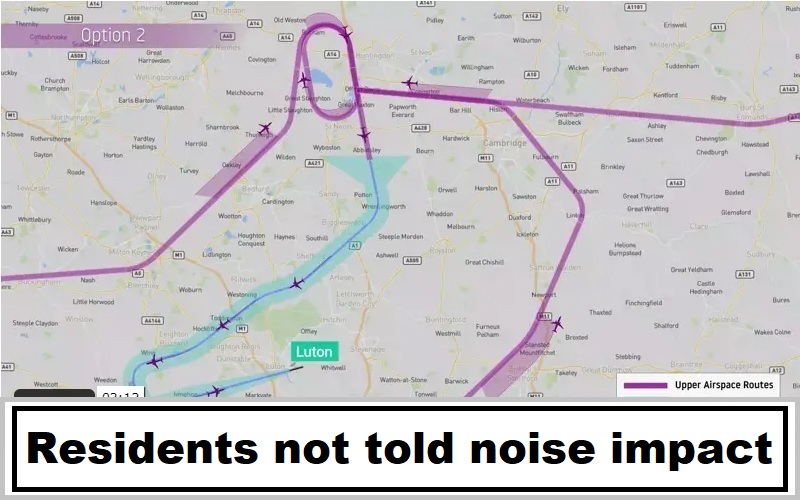
Luton Airport’s consultation on changes to arrivals flight paths closed on 5th February. The proposals would affect a wide area north of the airfield and include adding an old-fashioned holding stack above Grafham Water.
Our verdict on the consultation material is that it lacked a clear indication of the most important thing to people on the ground: “what difference will it make to aircraft noise where I live?” This is a fundamental omission when judged by the Civil Aviation Authority’s airspace change manual, CAP1616. The consultation documents were also very complicated for non-aviation specialists to understand – the very opposite of what is required.
LADACAN’s consultation response
On behalf of members of the Luton And District Association for the Control of Airspace Noise, and as active members of the Airspace Change Focus Group, we make the following representations in relation to the above airspace change proposal:
1) During Focus Group meetings we urged the change sponsors to provide a clear, accessible way for consultees to understand the information about aircraft noise and the change to the noise environment in their area arising from the proposal. Such clarity is required by the technical annex CAP1616A which says:
“1.39 The change sponsor should always bear in mind that the production of a large number of operational diagrams covering every eventuality in great detail has the potential for confusion.
The challenge is to present information on aircraft noise in ways that are clear and accurate, without omitting essential detail, but which can be readily understood by a non-technical audience.
Operational diagrams should be considered as communication tools with limited applicability in the assessment process. There is a proportionate balance to be struck between the amount of data produced and the degree to which this information actually helps the audience to understand the key issues.”
Instead, the Consultation Document includes a large number of operational diagrams and does cause confusion. It does not present clear and accurate information on aircraft noise: instead, it lists a complex set of instructions more suitable for a machine to follow, by which consultees were somehow expected to work out comparative noise impacts for themselves, partly based on recollection from more than a year ago.
2) CAP1616 itself says:
“154. Key consultation requirements are that:
– meaningful material is available in a form that does not require technical knowledge to understand and respond to it
– stakeholders reading the consultation – including those with no technical expertise – can understand the potential impact of the proposed changes on them, and any technical information is available in a form that does not require technical knowledge to understand and respond to it”
Our feedback on the consultation material was that people find it confusing.
3) The consultation document purports to provide comparative noise information using contour diagrams, but these fail to deliver useful information since the areas covered by the contours are not the area affected by the airspace change. Hence the impression is given that the impact of the change is negligible, which is inaccurate and fails to meet the standard required by CAP1616A.
4) The consultation document and associated map overlays purport to show the overflight densities, but again the information is inaccurate because no change is portrayed between dispersed and concentrated tracks, again failing CAP1616A.
5) The scale of the maps contour provided is in general inadequate for people to identify detail down to street level, so again fails to meet the requirements of CAP1616A.
6) This is completely unacceptable and inadequate, since it makes it impossible for people to respond based on information which the sponsors are required to provide, but did not. Given the impossibility of understanding the information provided, people were being urged simply to fill in set response combinations on the dumbed-down consultation form just depending on where they lived.
7) The declared justification for the prioritisation of this airspace change proposal is “safety” but it is clear, given the significant reduction in airspace traffic now and post-COVID, that airspace which functioned perfectly safely during the busy year of 2019 will certainly function safely until at least 2024. The urgency has therefore receded and time is available to consider the other factors weighing on the best design for this airspace, in line with the urging of Aviation 2050 to engage with airspace modernisation rather than the perpetuation of outdated ideas, an approach which is certainly portrayed as part of Luton’s future sustainability strategy.
8) In particular, emissions are a significant factor which cannot be ignored, and yet the proposal would increase emissions by an average 285kg per flight. Delaying the proposal until the use of Linear Holding and Arrivals Management have been introduced would be more sustainable. The whole rationale behind airspace modernisation is to eliminate holding stacks: this design and the needless rush to submit it perpetuates an outdated and inefficient procedure.
9) The first GPS-based concentrated route implemented by Luton Airport has not, in the view of those still overflown despite its misleading claims, delivered on its objectives. The CAA is aware that track-keeping is far from the controlled narrow band anticipated under RNAV for the simple reason that the vectoring of flights at 4,000ft disperses them to an extent far greater than consultees were led to believe. Whilst the current consultation document talks of Option 1 (dispersed) and Option 2 (concentrated), it mentions shortcuts but fails clearly to portray the likely effects of direct vectoring even with the GPS-based design, again misleading people.
10) Rural tranquillity is a significant factor particularly where new areas are overflown, and this proposal pre-empts the possibility of a more thoughtful design in coordination with Stansted as part of the national Airspace Modernisation project. As it is, residents of Huntingdonshire and these wishing to continue peacably to enjoy Grafham Water will find themselves newly impacted by Luton Airport if this proposal is implemented.
11) The sponsors have been innovative in setting up a virtual Town Hall to host the consultation material during lockdowns, but exploring that online space reveals that they have lacked any follow-through in using the space to portray information clearly and accessibly as required by CAP1616A. For example, there are virtual wall displays which could have shown maps of the different areas to be affected; instead the sponsors direct people to a virtual ante-room where they pick up the same documents that could have been downloaded from the website.
This suggests that the focus was never on improving communications, but more on ensuring that nothing should hinder the progress of the application. Which again suggests that the priority is the objectives of industry rather than the right of people to be consulted properly.
12) In relation to the overall desirability of the different routes and options presented for the transition between the holding area and the runway alignment area, we note:
a) Route 1 (Easterly) would significantly adversely affect the south of Leighton Buzzard and communities to the north east of the town due to the imposition of concentrated tracks.
b) Route 2 (Easterly) would similarly badly affect people living in the south of Leighton Buzzard and communities to the east and north-east of the town.
c) Route 3 (Westerly) is going to drive concentrated air traffic over Letchworth and the towns/villages immediately to the north of it, severely degrading their noise experience.
d) Route 4 (Westerly) will have an equally invasive effect on Steeple Morden and the villages to the north of it.
Yet none of the people who would be affected by these proposals have any reasonable means to ascertain the proposed change in their noise experience due to the failure of the sponsors to provide this information.
To conclude: this proposal should be withdrawn, reconsidered in light of all the comments above, and resubmitted only when it can be properly justified and its impacts adequately described in noise terms and constrained to be sustainable in emissions terms.
LADACAN’s guidance during consultation
Luton Airport is consulting on proposed changes to arrivals flight paths which could have a significant noise impact on residents over a wide area from Leighton Buzzard in the west to Walkern in the east. Their preferred option includes concentrated tracks rather than random dispersal of aircraft, which can mean people near or under the concentrated routes suddenly become aware of a lot more aircraft.
As far as people on the ground are concerned, this consultation and its hundreds of pages of technical documentation boils down to a simple question: are concentrated tracks or randomly dispersed flights the best solution when aircraft are passing closely spaced communities at low altitudes?
Random dispersal (Option 1) means potentially more people will hear aircraft, but not all the aircraft will be as close or sound as loud. On the arrivals flight path while the aircraft are being brought towards the “lining up” point where they make a final turn towards the runway, this is how it works at present. From that point onwards, the noise experience will be the same as now – a concentrated stream of aircraft.
Concentrated tracks (Option 2) mean fewer people may hear aircraft as they navigate towards “lining up” point, but those people are likely to perceive all of them rather than just the ones which used to come close. So effectively all the noise is dumped on the unlucky folk near the proposed concentrated route, and those further away will hear fewer aircraft.
The “refinement” to this is to have a couple of concentrated routes to choose from, and switch between them on different days. At the end of the day, the amount of noise is the same, it’s just a matter of how widely it’s spread. There’s nothing particularly “fair” about the process – all that can be said is that the aviation industry likes to use the new technology of GPS navigation to save air traffic controllers having to do so much work, and to make the routes more predictable. Where communities are widely spaced it’s a useful technology – where they are close, it’s impossible to avoid everyone. Which goes to show that Luton Airport is in the wrong place for massive further expansion – but that’s another story…
The consultation runs until 5th February, which is just as well because the documentation is not the easiest to get to grips with. There are various maps buried in the documents and a complicated “layered PDF” which illustrate the proposals. Mastering it all takes time and effort, so we have used the Airport’s data to create images giving a fair and balanced presentation of the alternatives below.
Have a look at these maps, find where you live, and consider what the noise effects might be. Have in mind the following questions:
* Am I currently affected by planes arriving into Luton Airport?
– If so, is it going to get better or worse according to these maps and options?
– If not, will I start to be affected according to these maps and options?
* Do I agree in principle that aircraft tracks should be dispersed over a wide area to share the noise, or concentrated so that fewer people get more of the noise?
In Option 1, the tracks are dispersed: more people will hear some of the planes some of the time.
In Option 2 the tracks are concentrated: fewer people will hear planes but they will hear more.
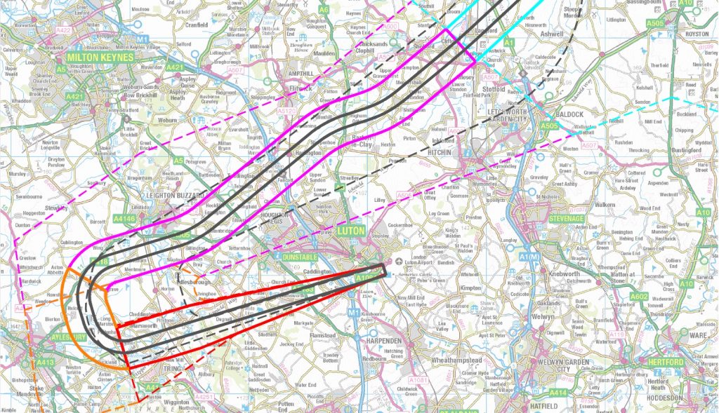
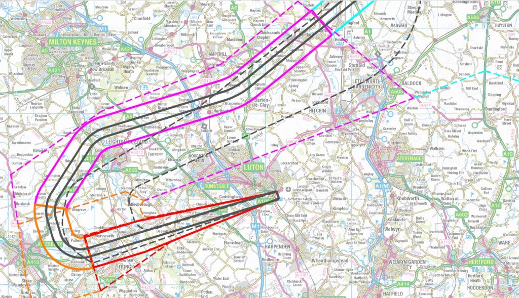
In all the maps, the solid-outlined light blue, mauve and orange areas will be increasingly noisy as the aircraft descend. The black lines show the centre of the proposed concentrated flight path in Option 2.
Westerly winds: Arrivals Option 1 (dispersed tracks)
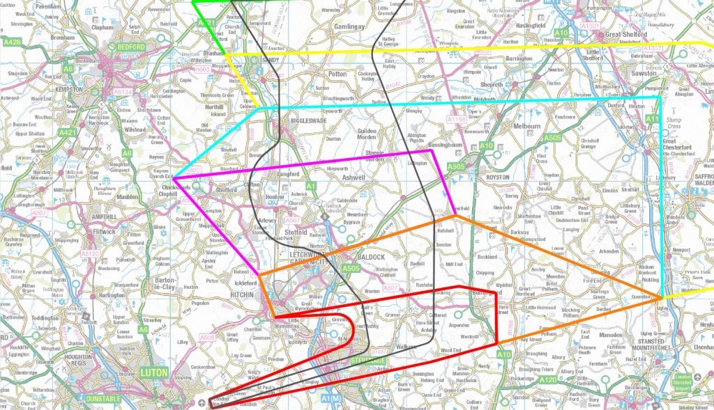
Westerly winds: Arrivals option 2 (concentrated tracks) Routes 3 and 4
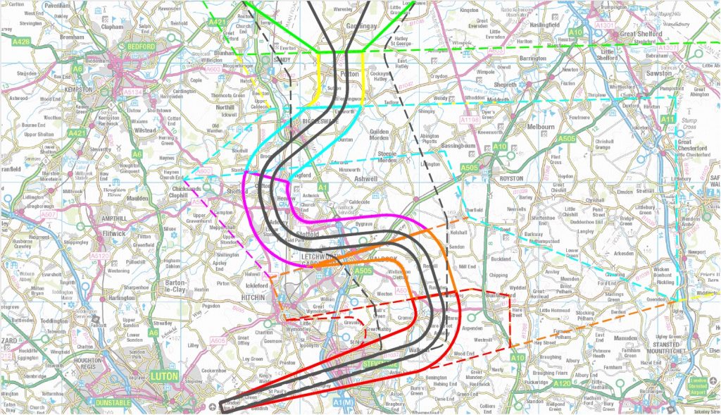
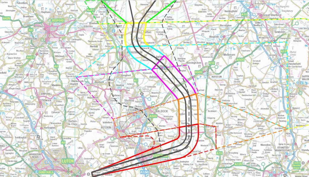
Easterly winds: Arrivals Option 1 (dispersed tracks)
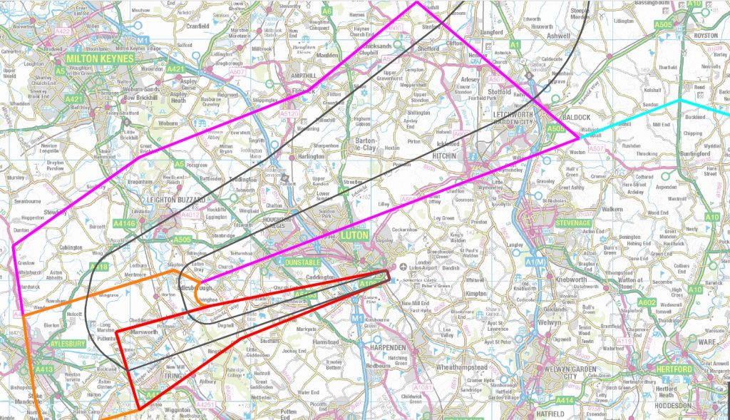
Easterly winds: Arrivals Option 2 (concentrated tracks) Routes 1 and 2
All the documents can be found at the link below, along with multimedia information. There are literally hundreds of pages, and lots of diagrams, but very little or nothing which makes it crystal clear what the changed noise experience will be in the affected areas. The Airport says it prefers the concentrated track option, but does not say why – essentially it’s so that the industry has the easiest solution. Whether this is at the expense of people on the ground is not made clear.
The online consultation boils all the complex possibilities down into a small number of rather crassly worded questions which don’t really do it justice. We will seek to provide more advice in due course. Meantime have a look at the consultation material provided and let us know what you think of the way in which it’s been presented and explained:
https://consultations.airspacechange.co.uk/london-luton-airport/ad6_luton_arrivals/
The online questionnaire can be found here: https://consultations.airspacechange.co.uk/london-luton-airport/ad6_luton_arrivals/consultation/intro/
As usual, it’s riddled with jargon:
“Vectoring” – this means Air Traffic Controllers guide a plane to line up on the runway, and flight tracks are typically dispersed.
“PBN” – this Performance Based Navigation means the planes navigate by GPS, a bit like cars, so the tracks tend to be much more concentrated.
Runway 07 (easterly) – they should be ashamed of using this jargon: what they mean is that people to the north and west of the airport will be affected by arrivals under these wind conditions.
Runway 25 (westerly) – again they should be ashamed of using this jargon: what they mean is that people to the north and east of the airport will be affected by arrivals under these wind conditions.
It’s worth looking at the questions without initially answering them, and then going back to the consultation material and our summary images, because the questions need to be answered carefully.
If you found this page useful please make a donation towards our running costs – we’re all volunteers. Those not yet members of LADACAN who donate £10 or more will be added to our emailing list so we can keep you up-to-date with this and other matters relating to Luton Airport environmental impacts.
Note that you do not need to have a PayPal account: the button will give you an option to donate using a credit card if you prefer. Many thanks.
This is a highly complex consultation and no attempt has been made to explain the actual noise impact on specific areas. The westerly routes into Luton seem to follow highly built up areas from the holding pattern near Huntingdon to descend directly over St.Neots, Sandy, Biggleswade and then Stevenage. When I put my post code in ( I live in Biggleswade) it says noticeable increase in noise but no more. When you are invited to leave a response some of the questions are technical and require readers to sift through an immense amount of detail ( I refer to how you might want airspace classified A,B or C). The danger of accepting either option is that Luton Airport then go all out for their increased passenger numbers so none of the promised respites will ever happen especially as flying times are likely to be extended.
The current westerly approach where aircraft turn to line up and descend from near Royston and then come in over Stevenage seems to work perfectly well. If they want to separate out the holding stacks keep the present one for Luton only and find another one for Stansted.
My hunch is this is to create capacity ahead of airport expansion, decoupling the noise impacts from the development consent process.
The proposals try to indicate that there are options, but where I live in Potton there are no options, all flights appear to overfly the town which can’t be acceptable. If the changes are to happen then we need to be given a break and either the PBN route altered so it flies over more rural areas or the vectored area is widened so everyone can share the load. Potton has a population of almost 5,000, schools and places of worship, not much of a deviation of the route would avoid us completely.
Rural areas are more noise sensitive. Dispersal is fair, offloading concentration onto others is not.
Government policy laid down to the CAA in the 2017 Air Navigation Guidance regarding noise is to “limit and, where possible, reduce the total adverse effects on people”. The method the aviation industry uses to do this is by concentrating the noise along a narrow track, with the planes flying themselves using GPS navigation. We are told that routes are designed to avoid population centres, but realistically in the south of England this just isn’t possible. (Even in Australia and Mid West USA there has been an major backlash to this “Performance Based Navigation”). Even if you do not live directly under the flightpath, but off to one side or the other, you will still hear the aircraft, being in the same place, just a little less loud. We will be told that the aircraft are not loud – all things are relative – but it is their metronomic impact which drives residents to distraction. Put anybody in a quiet room with a dripping tap and it will eat away at their sanity, even though the individual drips are not loud. I write this as somebody adversely affected by a recently imposed PBN departure route which passes directly over my home village of Sandridge. Before PBN they were dispersed and there was variability in their impact. I urge residents to take this threat seriously and act now – from experience, it is much harder to change something that has already taken place than it is to stop it from happening in the first place – but be warned, this is an industry that likes to get it’s own way and treats objectors with contempt.
I cop it equally for all options re so-called “westerly” so no need for me to comment on this particular proposal? Feels like I’m the one who gets all the noise so it is quite horrendous to see from the maps that there are so many other people affected, and over such a large area.
The only thing that will help me and others in this part of their route is quieter aircraft, and fewer of them, especially during the night.
Steven – there is going to be a significant on-the-ground difference in experience between dispersed (Option 1) and concentrated (Option 2) flight paths, so it is definitely worth looking carefully at the options and responding accordingly. And if your area is not particularly affected by arrivals at present, but looks like it will be, then make that point and your feelings about it known.
Considering that Luton Airport cannot continue to grow until it increases its limits of passenger numbers (in process but at least 16 weeks away), or expands its ground infrastructure (another consultation in process), and that COVID has currently depressed flight numbers, why not push this consultation back another year or two until they can demonstrate the need for another holding stack? It’s completely unclear from the proposal that this is required with present numbers, despite the subjective assessment that the current do-nothing option is unsafe. This seems to prematurely anticipate that Luton Airport will continue its trajectory of massive growth over the next decade, unchecked and with no environmental brakes whatsoever.
You are quite correct Michael. If the single holding stack was indeed “unsafe”, this process should have begun in 2013 when LLA began its march towards 18M passengers p.a. But like everything in this industry, it seems they will only invest in doing things which suit the short-term purpose of grabbing cash. That’s why the long-term strategy of redesigning the whole of airspace in the south-east is decade or so late, and still we get the ever-noisier departures from Luton regularly held low as far as Welwyn and beyond!
Spot on
Flights over Stevenage have increased massively over the past few years, causing distress to a large part of the population of the town. None of the proposed routes make any changes to the Stevenage residents only a complete reduction of flights such as been the case over during the pandemic would be preferred, a better route would be to the south over the less populated area of Knebworth and Welwyn North.